
Left rectangle ads redesigned


Robert Ripps book

History of Tribeca Buildings
Battery Park City’s new resiliency plans for Tribeca
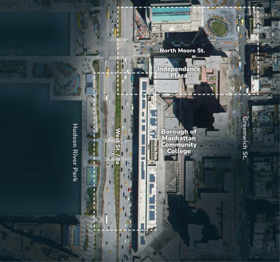
The Battery Park City Authority will host its latest resiliency design project update for Rockefeller Park and the streets of Tribeca on Thursday, June 20, at 6:30 at Stuy’s cafeteria. Register for that here. Or, if you want the news encapsulated for just the Tribeca part of what they call “Reach 1,” read on. I will do an update on the plans for Rockefeller later.
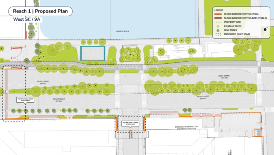
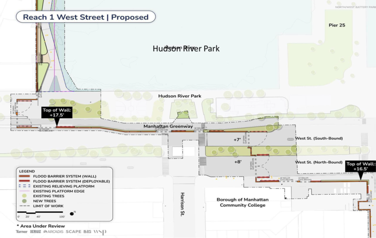
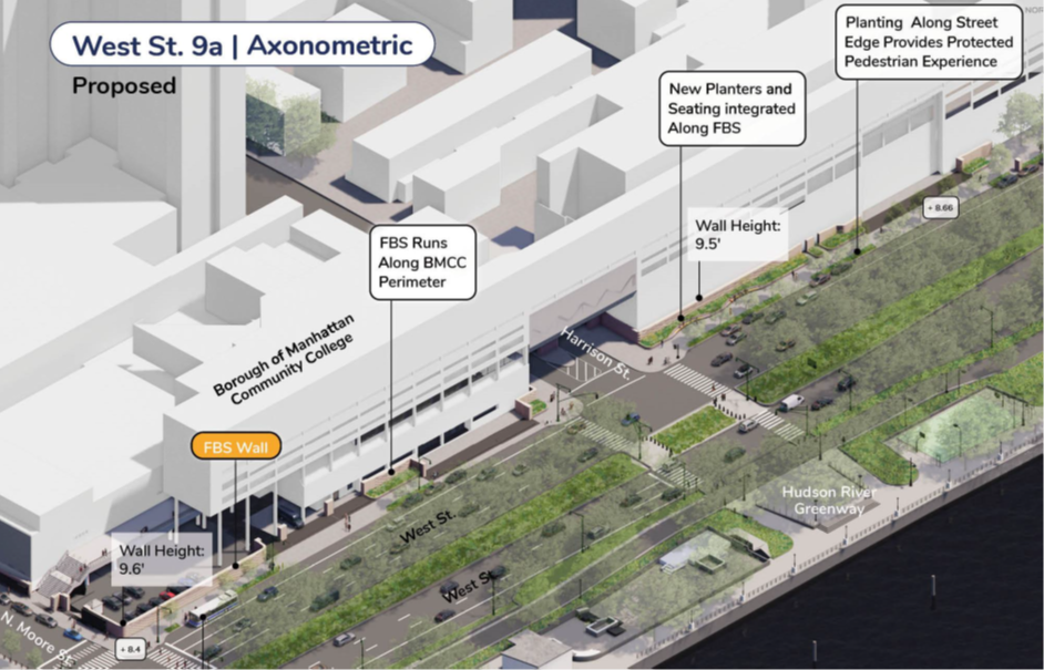
So, the headline: the authority is no longer trying to put up a wall along the bike path in Hudson River Park. Luckily that hare-brained scheme was, one way or another, defeated through the design process. They have also eliminated a lot of the walls that they proposed on Tribeca side streets, some that would have created tunnels for pedestrians on the sidewalk. Here are the broad-stroke changes since the last presentation:
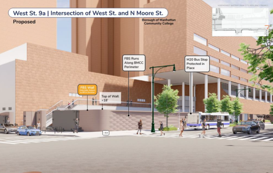
- The new deployable barrier across West Street will be located just north of Chambers, in alignment with the back side of Stuyvesant
- Floodwalls will then move up the west side of West Street, along the property lines
- Floodwalls will run along the exterior of BMCC buildings, and West Street will be elevated
- A deployable flood wall will cross the western end of Harrison Street at West
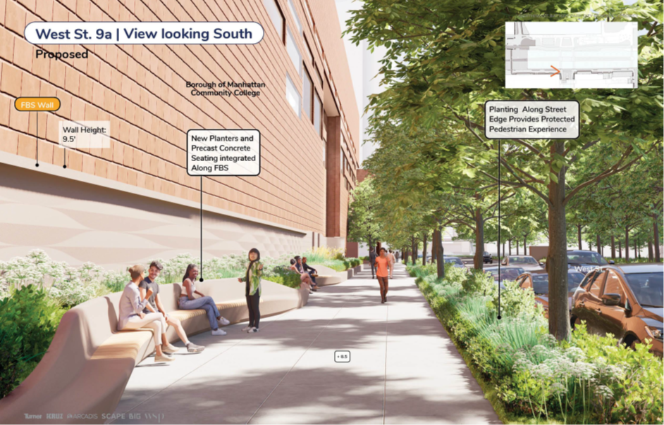
- The sidewalk along the east side of West Street will get seating and greenery
- Floodwalls will then trace the property line up to the south side of N. Moore, will it will make the turn and continue halfway up the street
- The wall height will be over 9 feet
This is a superior plan for all involved, and the improvement of the sidewalk along West Street seems like a good idea — that area is pretty gross and desolate now, since there is no street-level activity — though I am not sure how folks will feed the meters. (I don’t see anyone using seating along the Westside Highway, just as no one seems to use the western plaza at Citibank, but I guess it wouldn’t hurt?)
The material of the wall is still under discussion, though we might get more detail on that on Thursday.
This puts their design plans for this section, Reach 1, at 60 percent. Their draft environmental impact hearing with the city is scheduled for mid-September 2024; provided they are approved, construction would start mid- to late-2025.
8 Comments
Comment:
Medium rectangle #1 (top)

Right column rectangle ads


Restaurant guide icon


Are we building Flood Protection or a Jail? 17’5″ seems excessive for the former and just about right for the latter
I wish I could add the pic here I found on the NYC Flood Hazard Mapper because it details how the area from North Moore north to Canal and east as far as Collect Pond Park is one of the most serious flood zone with a base elevation of 11 feet. You can find it here: https://dcp.maps.arcgis.com/apps/webappviewer/index.html?id=1c37d271fba14163bbb520517153d6d5
The proposed plan provides for flood walls just south of there. So basically all of the flood waters will be directed into this area.
Please look this up. You will see that the current plan is total folly.
Keep in mind that their goal is to protect Battery Park City.
This entire concept of piecemeal opaque wall barriers seems not particularly well conceived given the scale of the actual problem (not to mention to the unintended consequences for other parts of the city pointed out by others), and effectively doubles down on the totally inhospitable nature of this (otherwise well-located) part of the neighborhood. A city as wealthy as NYC should be able to do so much better.
If we are going to proceed w these monster walls, can we at least include some greenery on the walls themselves? There’s a reason why almost no pedestrians use this stretch of road, it’s a depressing experience to walk anywhere near BMCC..
In no time at all, these walls will be covered with graffiti and sticker vandalism, and will therefore become even more of an eyesore.
Now imagine an 80 story tower just behind BM CC just South of Harrison street
These elaborate and expensive plans are based on the mistaken belief that BPC and Tribeca are at much greater risk than we were during Hurricane Sandy because the water in New York Harbor will rise three-to-six feet by 2050.
An inconvenient truth: The water is rising at a rate of only one-eighth of an inch per year. At this rate, which they claim is “accelerating,” it will take 288 years for the water to rise three feet.
exactly. the day to day risk is minimal. it’s the storms that are the big problem. if you were here in 2013, you can use sandy to gauge our vulnerabilities. battery park, the piers and west street are where the bulk of the flooding occurred. in tribeca, most of the damage was to underground structures near west street like the swimming pool at manhattan youth.