
Left rectangle ads redesigned

History of Tribeca Buildings
CB1 Tribeca Committee: The Unofficial Minutes (July 2013) | Part 2
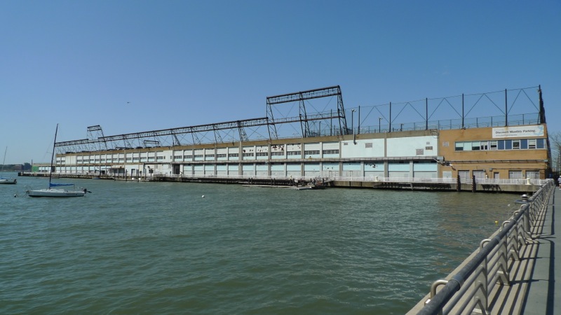 HUDSON RIVER PARK UPDATE
Madelyn Wils, president and CEO of the Hudson River Park Trust, was on hand to talk about the recent legislation. Most of this was in a previous post, but here it is again anyway. The legislation does the following:
1. Amends the boundaries of the park. The park has always gone all the way down to the Battery, along the West Street side; now it ends at Chambers. This is especially handy because all the bollards at Brookfield Place and Goldman Sachs make it hard for maintenance vehicles to get there—they have to call for permission, etc. Also, the Thames Street playground was part of the HRP, when it really should be BPCA.
2. Allows a passenger fee of up to $2 on cruises that use the park; this doesn’t include the passenger cruise terminal, which is on city property.
3. Transfers air rights from the park to buildings within one block of West Street/West Side Highway/etc. Wils said this isn’t just about 550 Washington—the huge building that straddles Houston—but that is certainly a major factor. There’s no telling how much money can be raised this way, because an adjacent site has to want to buy the rights and deal with the many layers of approvals.
4. Transfers the tow pound land to the park, requiring it to be 50% park, 50% commercial.
5. Allows Pier 54 to be built outside the original footprint, which is long but skinny—i.e., not great for recreation.
6. Defines “commercial use” in trust bylaws to include media studios, business offices, and more.
7. Permits mooring and docking of barges, so there might be programming on them.
8. Allows 49-year leases on commercial piers (but not Pier 40).
9. Allows for a slightly larger (10%) building on Pier 26. This would be about the estuary building, which Wils said she’d come back to, but she never got to it.
10. Permits a one-story heliport to be built on the water (vs. on land).
Then committee members asked questions. I’m going to distill the answers.
1. The legislation leaves Pier 40 with “no resolution.” It did not do everything Wils wished it had done.
2. Any transfer of air rights would likely financially benefit adjacent parkland; in Pier 40’s case, the money must go toward Pier 40.
3. The West Street median remains no one’s problem, so there’s not a lot of hope for it to get cleaned up. The trust has to ask for money every time it wants to work on it. (Structural issues are the responsibility of the New York State Department of Transportation, but not maintenance issues.) Wils said the median was one issue she hopes the Neighborhood Improvement District will help with. “A lot is broken there,” she said, citing irrigation as a major issue.
4. Friends of Hudson River Park is still pushing for the NID, but that’s not for her to discuss.
5. About Pier 26 noise: She said people should complain to the Heritage of Pride organizers, that the event wasn’t really “run by” HRP (not sure who did run it). She said if the community doesn’t want it and other concerts next year, the park won’t allow them.
6. The upland Tribeca section opens July 24, as you know.
TEMPORARY ART ON FRANKLIN STREET
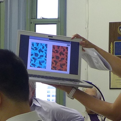
A city Department of Transportation rep said that the asphalt on the little block of Franklin that’s now closed because of Citi Bike racks is set to be painted by an artist. Two options were presented. People liked the one that looked like industrial upholstery (see pic below; those are leaves), not that the DOT plans on necessarily bearing the room’s opinion in mind. Of note: The DOT acknowledged that closing the street without ever running it by the CB1 Tribeca Committee was not the brightest idea (it had gone through the Planning Committee). Painting starts next month, because this is being fast-tracked, because obviously there are no other more urgent places the DOT could spend money. P.S. It got all of 21 submissions from artists, which as one member pointed out, proves they didn’t get the word out very well. The paint will be exterior-grade latex, and it’ll be there for a year, slowly fading over time. Also, the DOT plans on considering this idea at other Citi Bike locations. And one more thing: The DOT is looking at changing the “signal timing” at Leonard, where W. Broadway and Varick meet, so that cars coming down W. Broadway could turn right onto Leonard.
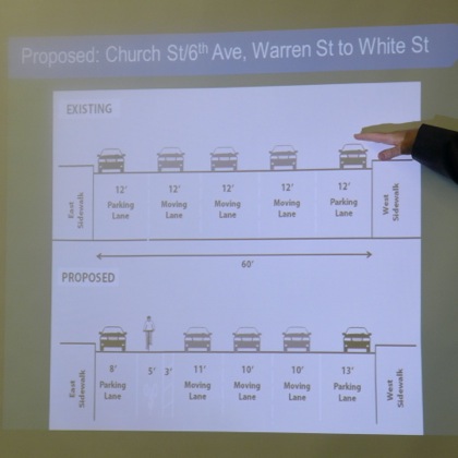
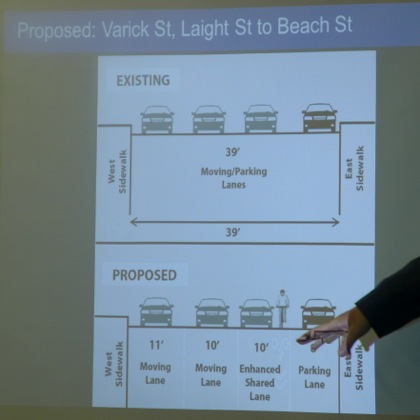
 TRIBECA BIKE LANES
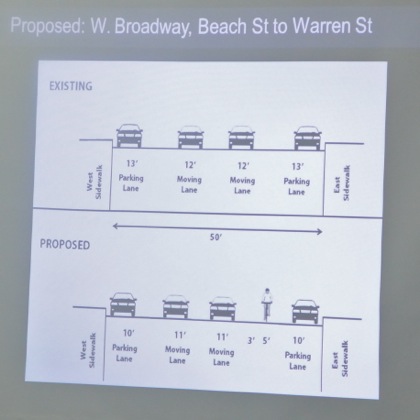
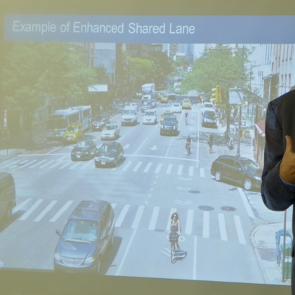
The DOT wants to put bike lanes on Church, W. Broadway, and Varick. The good news is that none have the parked cars out in the middle of the street. The bad news is that some of the lanes are for cars and bikes, and the lamest news is that on Varick, along the west side of Capsouto Park, because the street is cobblestoned, the DOT is making the sidewalk a bike lane. The committee was outraged that the park would be used in this way, even though pedestrians could always walk through the path in the western side of the park (and barely go out of their way to do so)—compare that with the nightmare of the City Hall shared bike path, folks. The explanation was that they might as well put it on the sidewalk because faced with cobblestones, cyclists will just use the sidewalk anyway.
No parking is sacrificed, probably because other city agencies would object. Seriously, the DOT could take a whole parking lane on W. Broadway and turn it into bike lanes, and the only folks affected would be the drivers of the countless city Priuses that park there. But that’s too easy. It’s a much better idea to shave down each of the traffic lanes, screw up a block of sidewalk, paint markings everyone will ignore (“the solid line is to tell drivers to stay out of the bike lane, but the dotted line means it’s shared”), and not push the NYPD for better enforcement of traffic laws. That was sarcasm, folks. Interestingly, however, the rep said that if CB1 objected, the DOT wouldn’t go forward with the plan (which is otherwise set to happen next month). This committee, however, voted 6-2 to approve it, with the stipulation that the sidewalk on the Capsouto Park block (which even I rarely walk on) not be used.

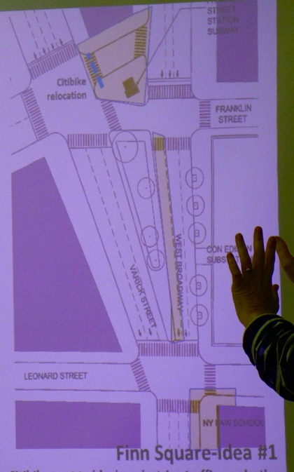
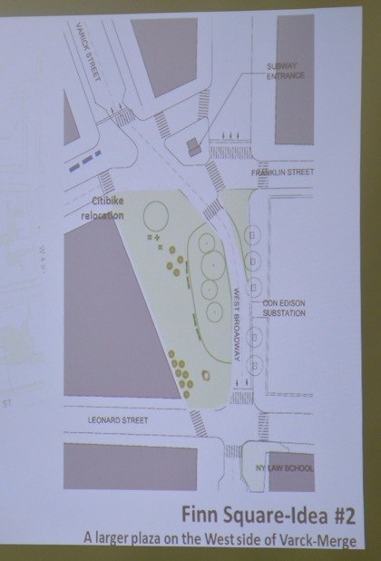
 FINN SQUARE PEDESTRIAN PLAZA APPLICATION
Lynn Ellsworth of Tribeca Trust explained that the group needs CB1 approval to meet the DOT’s July 31 deadline for what could be the city’s last Pedestrian Plaza program, but it doesn’t have a specific design yet—this is just to not be shut out. Predictably, a few members were wary of offering approval even though the ultimate design would have to come in front of them, but eventually it all got sorted out. Tribeca Trust did show a few possibilities (below): As Ellsworth pointed out, they’re just to illustrate how many interesting ideas people have for Finn Square. Note: She did say that the triangle in front of Tribeca Grand might be an area they think about next. Vote: 6-1.
4 Comments
Medium rectangle #1 (top)

Right column rectangle ads


Restaurant guide icon


Hi Erik,
Is there a schedule or date for when the bike lanes would be installed?
Thanks
Randy
@Randy: All they said was it’d be next month
To see Neighbors Against the NID’s analysis of the short- and long-term benefits of the changes to the HRP Act (and why we think they mean the NID is unnecessary), please go to nohrpnid.blogspot.com
Erik,
The idea of directing pedestrians through Capsouto Park is brilliant — is there a way for you get it to the DOT? If they painted signage on the sidewalk corner landing areas (north side showing bikes going on the sidewalk, pedestrians into the park; south side just directing pedestrians into the park) that would really make it work. I’m one of the admittedly few pedestrians who goes past there regularly and I find that crossing Canal on the east side seems much safer, but wouldn’t want to share the sidewalk with bikes once I got across. Maybe the change will even help some more people discover the charm of Capsouto Park.