
Left rectangle ads redesigned

History of Tribeca Buildings
BPCA will pursue design/build plans for resiliency in Tribeca and Rockefeller
The Battery Park City Authority just start construction on its resiliency efforts at the ballfields — a $7 million project that entails construction of 800 feet of flood protection systems along the Warren, Murray and West streets. Construction will be completed this fall and will not substantially impact play on the fields. See more details here.
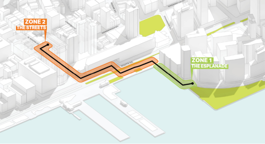
The South Battery Park City Resiliency Effort will wrap up in 2024 and includes a reconstruction of Wagner Park and flood protection for the Museum of Jewish Heritage. But the final piece of the authority’s plans for flood protection are the areas around Tribeca and North BPC, which they are now combining as the North and West Battery Park City Resiliency Project. The authority has decided to change tact there a bit from when they started last summer and move forward with a design-build plan that takes in both areas, with project definition and environmental reviews starting this year.
“Ultimately we want the contractor to look at that design as a whole,” said Gwen Dawson, BPCA’s vice president of real property. “It’s likely that it is something the same or very similar for the street infrastructure, but we decided to combine north and west projects.”
The plans there will cross over West Street and go as far as N. Moore, installing barricades along the highway and on side streets, requiring negotiations with all those stakeholders along the way — Hudson River Park, BMCC, State DOT, City DOT, private buildings and a whole other list of alphabet soup.
“The objective is to connect natural high points,” said Dawson. “On the west, it’s already high — so we would connect to the east with a barrier system. But as we get closer and closer to the high point [on N. Moore] the intervention gets smaller and smaller.”
The West BPC section will be protected by using existing park and retaining walls.
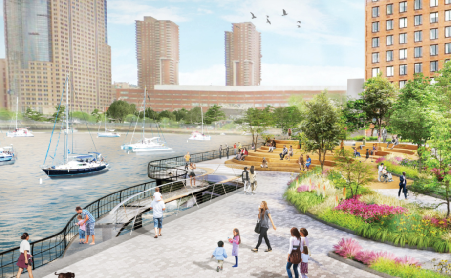
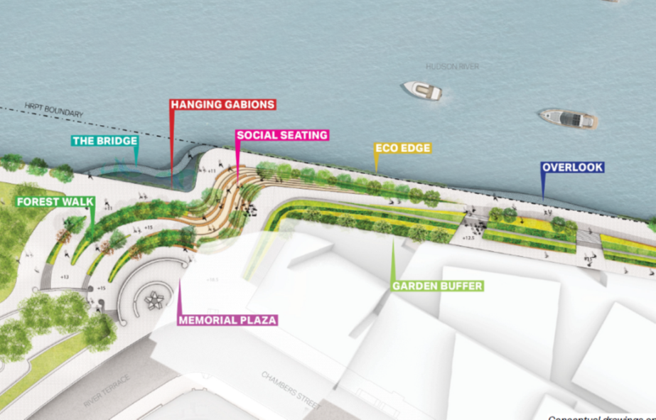
The drawings here were from the original concept plan for the North section, presented to CB1 last July. So while these don’t really count, they give you a sense of some of the concepts that might be applied.
More TK as the process rolls out.


16 Comments
Comment:
Medium rectangle #1 (top)

Right column rectangle ads


Mega rectangle

Restaurant guide icon


What’s the thought process behind terminating this at N. Moore as opposed to Canal, Houston, or higher?
My limited understanding is that Army Core of Engineers is responsible for studying those areas further up the Hudson, but shouldn’t the two plans integrate with each other?
BPC could probably skip most of Zone 2 plan if ACE keeps building protection up along the Hudson.
October 2019: ” […] Alice Blank, chair of Community Board 1’s Environmental Protection Committee, asked why Canal Street was not considered as a northern-most alternative for Tribeca. ‘It seems like the obvious place for demarkation, and it was one of the most acutely affected areas,’ she said. ‘It seems like a missed opportunity.’
“Dawson said the Authority’s mandate is to protect Battery Park City properties, and that’s what justifies the bonded funds that will pay for it. ‘We’re going to end up protecting other assets in Lower Manhattan as well,’ she said. ‘But without doing that we wouldn’t be able to protect Battery Park City assets.’
” ‘From a very technical standpoint,’ added Garrett Avery of AECOM [consultants, hired by the Battery Park City Authority, to come up with a plan for preventing a massive future storm from inundating the north neighborhood], ‘North Moore Street is a very clean alternative given our mandate and our ability to operate on behalf of Battery Park City.’ […]”
http://www.tribecatrib.com/content/some-tribeca-battery-park-citys-plan-its-flood-protection
Also in our conversation, N. Moore is the first point high enough to match the heights in BPC north. It’s my guess also that according to state law, the authority cannot extend/expand its mission beyond protecting its own property.
What people seem to be missing is that this project is to protect ONLY BPC. This project was not meant to and does not protect Tribeca – it floods. As waters are pushed by the flood walls away from BPC , stopping at N Moore, where do you think they will go? N Moore and south through Tribeca and Hudson River Park, that’s where
If my bathtub only had three sides water would come pouring out the empty area. North of North Moore street is that empty area.
Not if your bathtub floor is sloped down from the empty area. This is more like a swimming pool with a deep end and a shallow end. (There are even zero depth entry pools where the water clearly does not pour out.) Manhattan island features differences in elevation.
There is a deep trench, or inlet if you will around the area between North Moore Street and Canal Street. Terrain, unlike bathtubs with slopes, is uneven.
During Hurricane Sandy theses areas experienced alot of flooding. If the area south of here is protected, might the resilience project funnel water into this area which extends from Canal/North Moore rather far inland?
Exactly my concern
In my brief conversation with the BPCA, I asked that same question. They said they had studied this, and if there is a wall at Harrison, the flooding levels north of that, since they will spread far and wide, will be negligible — fractions of an inch. However, as this process rolls out, this to me is the question to ask, along with what the permanent walls look like within Hudson River Park and elsewhere.
This presentation has done nice illustrations of the permanent and deployable flood barriers.
https://bpca.ny.gov/wp-content/uploads/2020/07/200723_NBPC_CM_3_FINAL.pdf
Here are a couple of useful flood maps.
This one shows areas flooded by Hurricane Sandy:
https://www.nytimes.com/newsgraphics/2012/1120-sandy/survey-of-the-flooding-in-new-york-after-the-hurricane.html
For those who were in Tribeca at the time, does that one seem accurate?
This is a general flood risk map for NYC:
https://www1.nyc.gov/site/planning/data-maps/flood-hazard-mapper.page
Greenwich Street is the historic 1776 Hudson River coastline, hence the flooding seen.
Canal Street west from Lafayette St to the Hudson was the route of the (now-covered) canal originally intended to drain Collect Pond. The flooding reflects that also.
Am I the only one who is thinking about this…THE RESIDENTIAL AREA BETWEEN WAGNER PARK AND TRIBECA AND NORTH BPC. That area cane within a few feet of being flooded out by Sandy: thousands of residents displaced for countless months, lives broken and financially damaged, and hundreds of millions of dollars in damages. Why are we talking about every area BUT that? The fact that its complicated and will be expensive is the reason you deal with it first, not last. The reason the tragedy of another Sandy will impact the most residents makes it a priority. I guess the mantra of political leaders reigns supreme: there is always time to put off a major decision.
BPCA is doing its resiliency work in stages. That stage is almost ready for the construction phase and the northern end is last. You can read about it here.
Thank you…but to my point, I went to BPC website and found the following, undated of course but I assume current:
The combined North & West Battery Park City Resiliency Project will proceed through a progressive design-build effort. Project definition development and environmental review will commence in 2021, with a with a contractor to be selected in early 2022.
Thus 10 years after the fact they will be SELECTING A CONTRACTOR. Anyone familiar with bidding practices knows you are way off from shovels in the ground..way off. Of course, maybe a contractor already selected??? In any event, the most densely populated area of the BPC Resiliency Project is not even close to “boots on the ground “.
I’m not following your 10 years comment, but yes, you have the same thing here as was in my post. North & West will have a design/build contractor as of early next year. The South section has already begun; the ballfields are under construction now.