
Left rectangle ads redesigned

History of Tribeca Buildings
How to weigh in on BPC resiliency measures for Tribeca
The Battery Park City Authority is close to hiring a design/build team to take on the reconstruction of the areas from the South Cove to Rockefeller Park and parts of Tribeca. They could have the team in place as early as August, and are shooting for construction to start in fall 2023 and end in fall 2026. (NB these dates were sketched out by the BPCA with a consulting engineer and will be refined once the team is in place.)
If you want to comment, do it by Sunday here on their virtual hearing site. Or if you want to just lurk for now (there will be other opportunities for public comment once the design team is engaged) I have tried to summarize the plans for the northern-most sections of the the park below. You can also email your comments at anytime to nwbpcrinfo@bpca.ny.gov.
The project is intended to reduce the flood risk related to future storm events and sea level rise for Battery Park City residences and businesses. And to do that, they are rebuilding their park system along the bulkhead and designing various flood protection systems along the way.
Sandy scared everyone straight, but while Battery Park City was not devastated by any means ($10 million in damages, mostly to the ballfields) they are assuming the worst is yet to come. “We know that these storms are getting more severe and more frequent, so the level of impacts that we want to protect against is something greater than Sandy,” said Gwen Dawson, BPCA’s vice president of real property. “We saw the water come ever so close to breaching the upland area. With a little bit more surge, or sea level rise, then the results can be more devastating.”
If you can take it, read on for a simplified reduction of the plans, and at the bottom, a bit of the controversy being led by neighbors in Battery Park City.
THE MONEY
The budget for the North-West Resiliency Project is $630 million, which they will finance with bonds. (The South BPC Resiliency Project that includes Wagner is $221 million.) The revenues the BPCA collects from rents and PILOTs (payments in lieu of taxes) will pay the debt service. Right now, BPCA generates a significant amount of revenue in excess of its operating needs, which flows to New York City. (Since BPC is built on state property, there are not property taxes paid to NYC, hence the PILOTs.) As a result, there would not be any impact on the ground rents paid by residents; there would just be a decrease in what flows to the city.
THE OVERVIEW
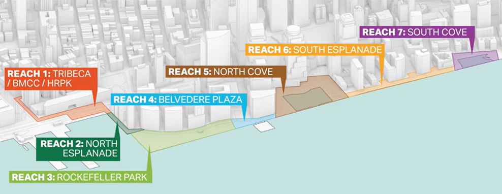
The BPCA has posted a “virtual open house” where you can add your comments to each section of the project, which they are calling “reaches.” You can watch a 9-minute video that gives you an overview here, and then you can click on each reach to add your comment. It looks like a lot, but once you click you will get it.
THE PLANS
TRIBECA (REACH 1)
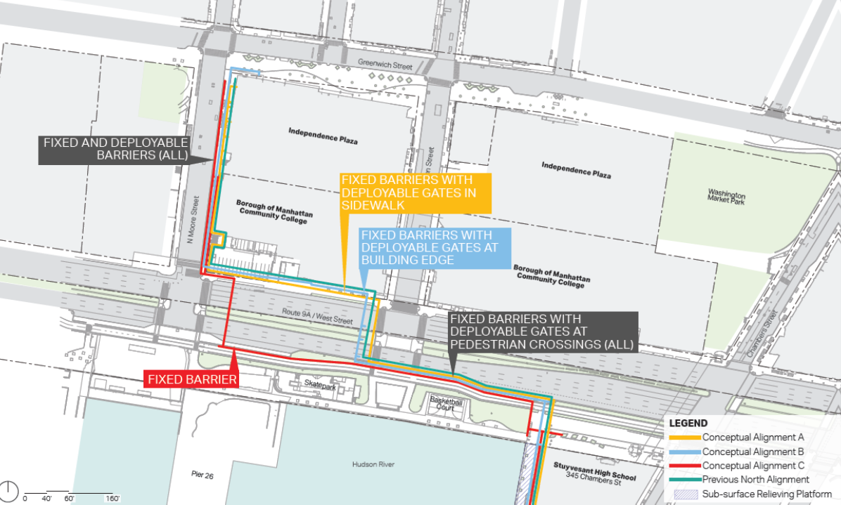
The BPCA is asking the design team to figure out where and how to place flood barriers in both Hudson River Park and the streets of the neighborhood to keep river water from flowing in from the north of Battery Park City. They are suggesting four different routes for arrangements of 10-foot fixed flood walls along with a network of deployable barriers. These would reach as far as N. Moore and Greenwich.
The colored lines in the drawing above correspond to four different route options for the fleet of walls and barriers. There would, of course, have to be discussions with a lot of stakeholders: the city, Hudson River Park and BMCC.

NORTH ESPLANADE (REACH 2)
This area behind Stuy would be reimagined as an elevated esplanade and seating area. There is an option to widen it. It would also have fixed 4-6-foot walls on the southern perimeter.
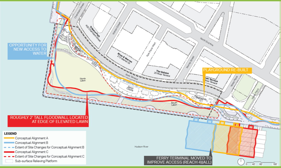
ROCKEFELLER PARK (REACH 3)
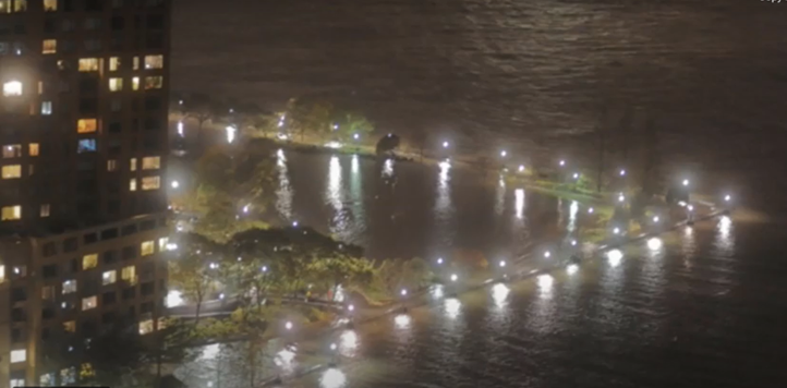
This is where the rubber hits the road. But there are three options: option A (yellow line) puts a wall on River Terrace so there are few changes to the park itself — it just gets exposed to the flooding (as it did in Sandy — see pic below). Option B (blue) elevates all of the park and buries a floodwall below the green space; and option C (red) elevates the lawn only and puts an 8-foot deployable flood wall to protect the courts.
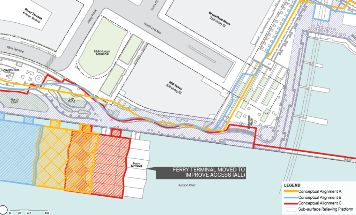
BELVEDERE PLAZA (REACH 4)
Similar to Rockefeller, the plans here would either elevate the whole area including the lily pond, or install an 8-foot flood wall around the eastern perimeter. There will be consideration of moving the ferry docks to improve views and access.
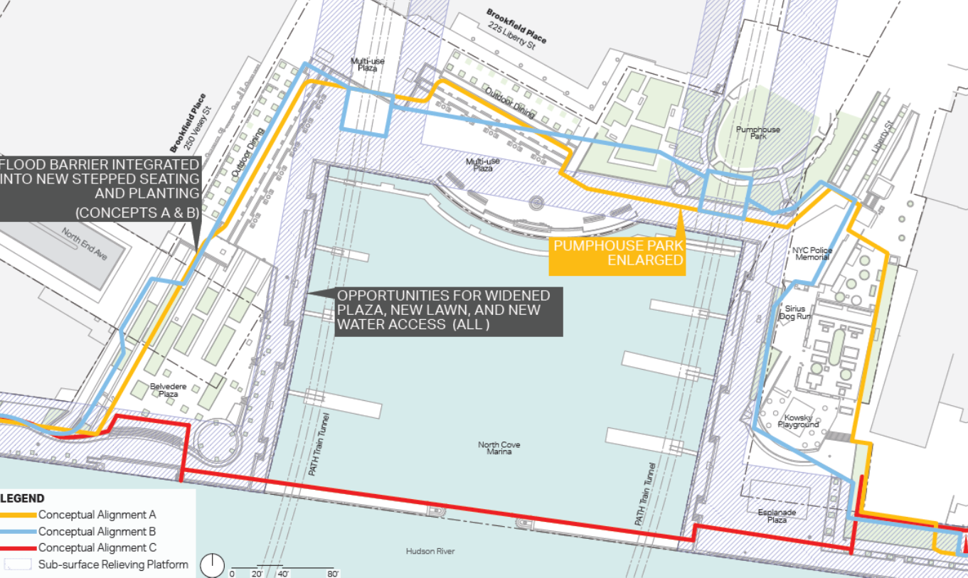
NORTH COVE (REACH 5)
The options here seem to be either buried floodwalls (option A, yellow) or changes to the elevation with some buried floodwalls (option B, blue) or minimal changes with 12-foot deployable flood walls (option C, red).
THE FINE PRINT
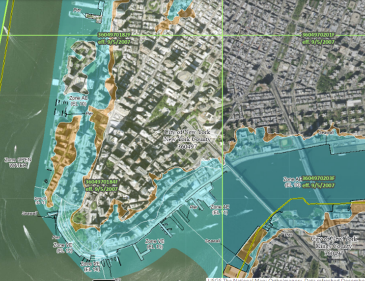
The Battery Park City Neighborhood Association has argued — and continues to argue — that the BPCA is using a more aggressive projection for future floods — in other words, they are assuming that more work needs to be done than is necessary, and that the agency is overstating the flood projection by two feet — from 9 feet to 11. (You can extrapolate from there, but some have suggested that a lot of this is just make-work for the planners and the engineers involved.) There is disagreement between neighbors and the BPCA execs about what standard FEMA requires for insurance purposes.
The BPCNA notes that the city appealed FEMA’s proposed flood insurance rate maps, and FEMA agreed, and that BPCA should use those standards and maps. But the BPCA executives argue that they are complying with the city’s Local Law 96 by using the more severe maps.
“It’s consistent with the New York City Panel on Climate Change and they collect all the best scientific data that’s out there,” said Dawson. “We are using this for long-term planning purposes, and proponents of projects in the city must adopt the more extreme flood maps. Every project that is being proposed in New York City is using these same projections.”
The image below is taken from FEMA’s National Flood Hazard Layer Viewer, a geospatial database that contains current effective flood hazard data.
3 Comments
Comment:
Medium rectangle #1 (top)

Right column rectangle ads


Mega rectangle

Restaurant guide icon


Hi Tribeca Citizen, thank you for your ongoing coverage on this important topic. Do you know which design team was hired for the North West?
They have not been selected yet.
Thanks so much. What I understand in a late game move, SCAPE and BIG were brought onboard. BIG helped design the original community-backed ESCR plan (that ultimately was scrapped) and SCAPE is an expert on using nature-based approaches for resiliency. The design principles laid out are the exact ones the community has been asking to be applied to Wagner Park. We are glad they are being adopted for the Northwest and ask for them to be applied to Wagner Park.