
Left rectangle ads redesigned

History of Tribeca Buildings
Seeking clarity on the Governors Island plans

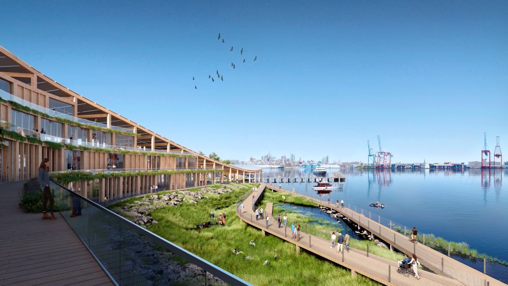
The New York Climate Exchange © SOM | Miysis
I found the new renderings released for Governors Island confusing: they included just 400,000 square feet of development when the rezoning allows for 4 million square feet of development. The renderings show the new buildings surrounded by trees, which didn’t seem to make sense. And sure enough, this is just the beginning. There’s a lot more development in store for the island. (Maybe everyone else got this and I am the only one lagging behind!)

The New York Climate Exchange © SOM | Miysis
The “Center for Climate Solutions,” which was created when the southeastern part of the island was rezoned, is a 33-acre development site; this plan announced so far is called the “New York Climate Exchange” and is just five acres of the bigger site. It also includes three historic buildings, including Liggett Hall, the brick one with the arch near the food trucks. In the future there will be more RFPs to find developers and tenants for the remaining parcels — 28 acres and the option for 3.5 million square feet.
The rezoning also extends the mix of uses (education, commercial, non-profit and amenities that support them, like housing) to the historic district on the island. The Harbor School will also expand with a new facility in the Western Development Zone.

Skidmore, Owings & Merrill is the design institution working with Stony Brook University on this plan, and the renderings here are from the most recent release.
The New York Climate Exchange © SOM | Brick Visual

The New York Climate Exchange © SOM | Miysis

The New York Climate Exchange © SOM | Miysis

The New York Climate Exchange © SOM | Brick Visual

The New York Climate Exchange © SOM | Miysis
All this sent me down the rabbit hole that is the designation report for the Governors Island Historic District, to see what I could learn about Liggett Hall, which is part of this first-stage plan, and I am regurgitating some of it here for the record.
In 1900, Secretary of War Elihu Root first proposed the expansion of the island — to build a seawall around the perimeter and to accommodate at least one battalion of troops, with barracks, offices and a hospita1. New York architect Charles F.
McKim of McKim, Mead & White got the gig, and presented plans to President Roosevelt in the summer of 1902.
The McKim, Mead & White plan called for the elimination of nearly all existing structures (Castle Williams, Fort Jay, and the South Battery were spared demolition) and introduced the Beaux-Arts planning principles that they were known for, with symmetry and cohesion. The plan included a 1,700-foot parade ground in the center of the extension; two loop roads, lined with barracks and other housing, ringed the parade ground.

Governors Island Historic District
The extension of the island was funded by Congress in 1902 using fill from subway construction as well as materials dredged from the harbor. (The State of New York had ceded the under-water land to the federal government in 1880.) THat was completed in 1912, but then lack of funds and World War I delayed building construction.
“In its annual report of 1914, the American Scenic and Historic Preservation Society reported that despite the comprehensive plan
of 1902, Governors Island’s fate was again in question, as the Secretary of War proposed to reduce Governors Island to a corporal’s guard. The year before, a resolution before Congress had proposed selling the island to the city for use as a park.”
That happened eventually, just nine decades later!
Liggett Hall was the first housing for officers’ families constructed in accordance with the plan and was constructed in 1928.
3 Comments
Comment:
Medium rectangle #1 (top)

Right column rectangle ads


Restaurant guide icon


So long Governors Island! Grateful I had a chance to take nice breezy walks among the dilapidated historical houses and lavender fields before the vultures finally descend upon it.
agreed, it was a gem, its a shame theyre bastardizing it.
This is a giant handout to corporations that will be allowed to squat on and profit from our resources. Outrageous.