
Left rectangle ads redesigned

History of Tribeca Buildings
The Latest: Battery Park City’s resiliency plans for the streets of Tribeca
Battery Park City Authority hosted its latest community meeting on its plans for the North West CHECK corner of its property last night — and the plans still call for a wall running down the bike path of Hudson River Park as well as a reworking of the platform that leads from Hudson River Park to Rockefeller on the backside of Stuy.
I will say the planners — a big design-build team led by Turner/EE Cruz construction — seemed to have a much lighter touch this time than they did for the southern part of the neighborhood, where Wagner Park has been completely leveled. (I was shocked to see nothing but sky when I looked west from the bike path at Pier A.) Their M.O. for much of Rockefeller and the areas south — the playground, the lily pond — is to expand on existing walls to the east of the park areas, rather than rebuild the parks themselves, or as they said, “leverage what is there.” So here goes:
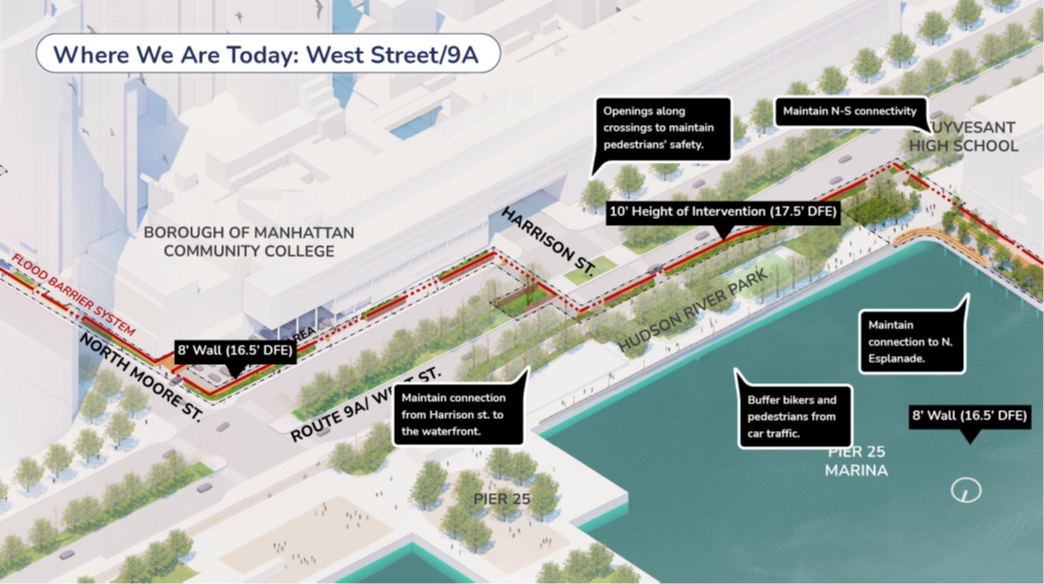
THE WALL ALONG THE RIVER
The plan for Tribeca’s streets — at a planning stage of 30 percent — remains largely unchanged. It still calls for a wall along the east side of the Hudson River Park bike path from Chambers to Harrison, where the wall then crosses to the east side of the highway and snakes up to N. Moore, where it continues to Greenwich. (The presenters at first said the wall was intended to protect the streets of Tribeca, but when asked directly they confirmed that this plan is intended to protect Battery Park City alone. Any protection of Tribeca is an accidental benefit.)
As of now there are two options (above and below):
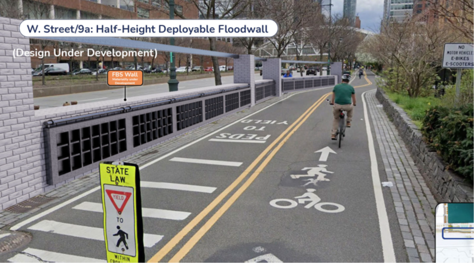
1. Build a half-height wall with a deployable wall built inside that lifts up when the flood comes.
2. Build a planted wall with steppes that is less imposing than a flat slab.

I asked why the wall could not be built on the east side of the highway, and they said that plan, which would extend the flood barrier southward on the east side of West Street would:
- require an additional deployable gate across a city street (Harrison);
- pose a series of significant technical challenges due to the extensive utilities and other large Con Ed infrastructure adjacent to BMCC further south; and
- significantly complicate both pedestrian and service access to the BMCC campus.
Now, I don’t see why this is not a completely accessible trade. The choice to build a wall that parkusers will experience every single day for all time vs. deployables that will be used once every 10 years seems illogical.

WALL ALONG N. MOORE
Not sure why they were ever considering building a wall along the curb to create a tunnel (well, no ceiling) out of the N. Moore sidewalk, but that is now off the table and the wall will hug the IPN property instead. Assuming there have to be deployables for the BMCC parking lot at the West Street corner, which they could do more of when they move the wall from the park to the edge of the highway!
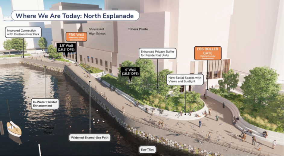
THE ESPLANADE
The authority plans to completely rebuild the deck that is the esplanade walkway going east-west along the backside of Stuy. The retaining wall under the platform will be reinforced, the platform extended, and they will in the process improve the choke points that are the corner with Hudson River Park and the right angle at the start of the gardens, just west of North End Avenue. Of the three design options, they are leaning towards “the wave.”
This will be some serious construction, but it won’t require taking a lot of park offline. It will require some permitting for building out over the water, since that is the Hudson River Park estuary and is protected.

ROCKEFELLER PARK
The lawn will remain largely untouched and the presenters said there will be minimal disturbance for park users. The contractors said the existing retaining wall is high and strong enough that they can leave it unconstructed, and just add some drainage improvements for the lawn, which it needs even now.
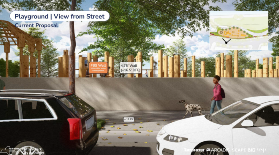
THE PLAYGROUND
Again, the plan here is to “leverage what is there,” but in this case it is to build the current hip-height wall that runs along the western sidewalk of North End Avenue to a 5-foot wall. (You can also think of this as the wall on the east side of the playground.) It’s not pretty in the rendering, but they said this was just a preliminary sketch.
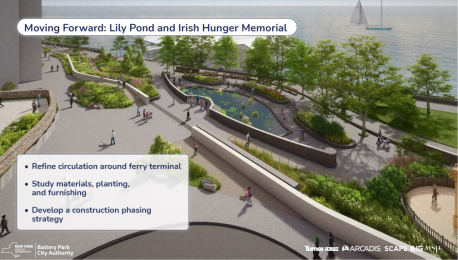
There are more plans for further down (see the Lily Pond and Irish Hunger Memorial below, but this was as much as I could bite off for one post.
I did not stay for the entire meeting — you can watch it here or see the presentation yourself here — but I did catch a question about financing: since BPC does not pay city taxes, but rather pays some of its excess revenues in the form of a PILOT, or payment in lieu of taxes, it will divert some of its revenues from ground rents to pay the debt service on the bond issue for this project. Residents will not see an increase in rents. “There will be plenty of revenues to cover the debt service,” said Gwen Dawson, senior vice president.
She also added that Battery Park City Authority will assume the cost of the entire project and not ask other property holders within the scope of their efforts to chip in, otherwise “we would jeopardize our ability to get it done.”
9 Comments
Comment:
Medium rectangle #1 (top)

Right column rectangle ads

Restaurant guide icon


These walls are just disastrous, especially the ones along the bike lane and sidewalks. It’d be really helpful to have the existing views compared to the proposed renderings documented.
I’m also extremely concerned by the lack of a planned interface for areas north of N. Moore. Won’t these walls just worsen flooding in that area since the water has to go somewhere? I don’t see how it’s legal for the state to make a decision like that—to protect one area at the direct expense of another.
It makes no sense to approach this problem piecemeal with very expensive, potentially unsafe and unbelievably ugly walls; there ought to be a moratorium on any concrete wall construction along the NYC waterfront until the city collectively decides, following consultations with international (read: Dutch) water management experts and feedback from the local community, on a long-term solution that doesn’t create more problems than it solves.
Also worth noting that the Canal Street area, a former swamp and floodplain, is the natural low point along the west side of Manhattan. Walls built for BPC only will exacerbate flooding for the rest of TriBeCa and lower Manhattan.
What is being done to graffiti-proof these walls? The design looks like a massive blank canvas for vandals.
Are we all on Candid Camera? I’m waiting for somebody to jump out and exclaim, “Just kidding! Nobody would ever build something this stupid! We just wanted to see your reactions!”
This wall is one of the dumbest ideas I’ve ever seen in the public dialog. There is a 100% chance it will quickly become a vandalized, weed-covered, crumbling eyesore that will serve to provide cover for quality-of-life lowering activities. I have very little faith that anything “deployable” will actually be functioning with staff that is prepared for a rapid deployment the next time a storm is bearing down on NYC. So who knows if this ill-conceived storm protection will even work when needed.
Don’t try to recreate the wheel here, just use the existing technology: a levee. Build a 5-10 foot mound running north-south, cover it with grass and throw a walking path on top. Problem solved.
Exactly my thoughts. Well said.
10-foot mounds tend to block views and would take up half the existing park. Goodbye playground!
I’d rather have my view blocked by a landscaped hill than a wall. Are you making the case to do nothing?
Great idea NO ridiculous WALL!!
Excellent idea!