
Left rectangle ads redesigned

History of Tribeca Buildings
Nosy Neighbor: Why Are Tribeca’s Street Numbers Messed Up?
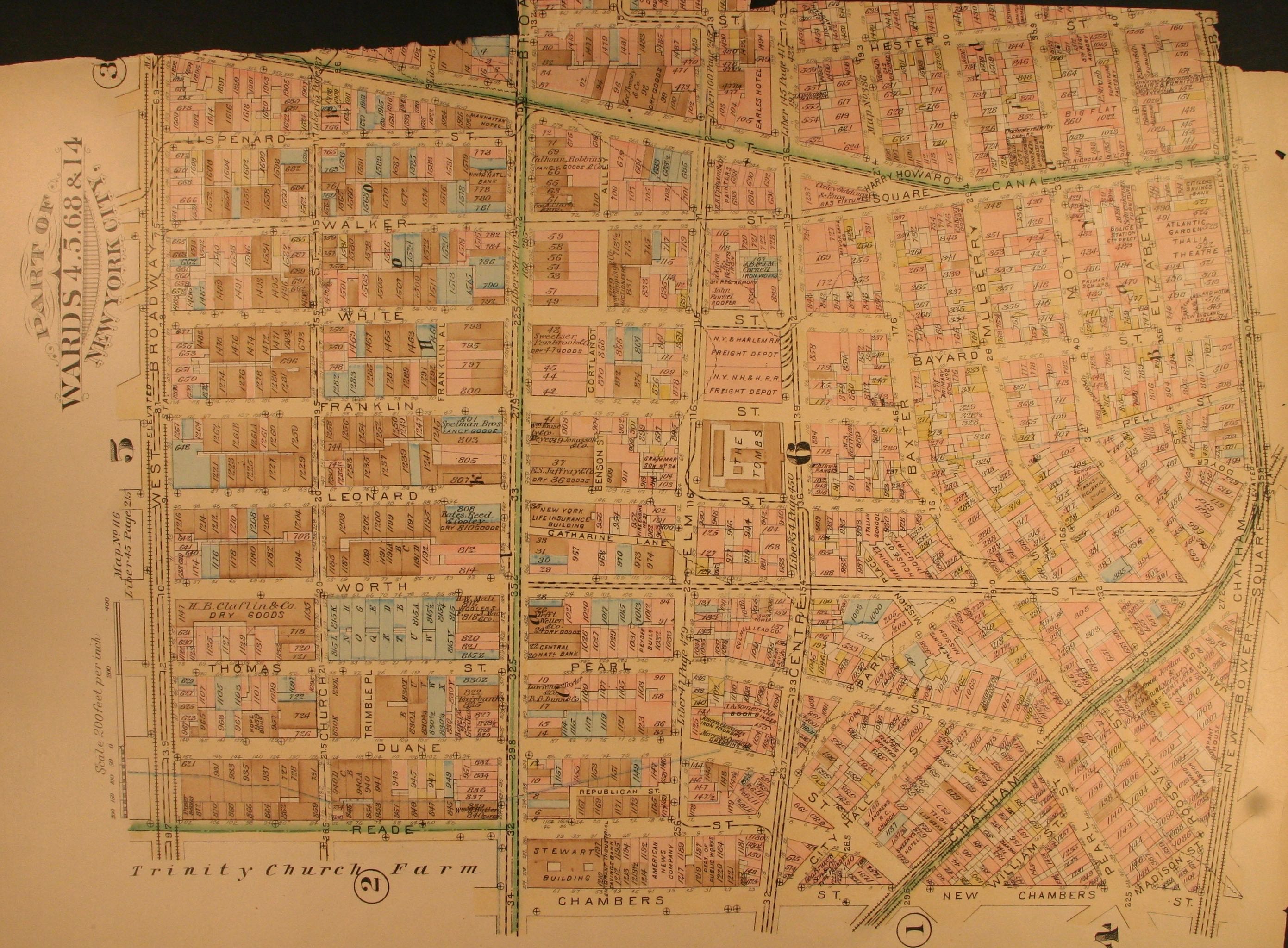
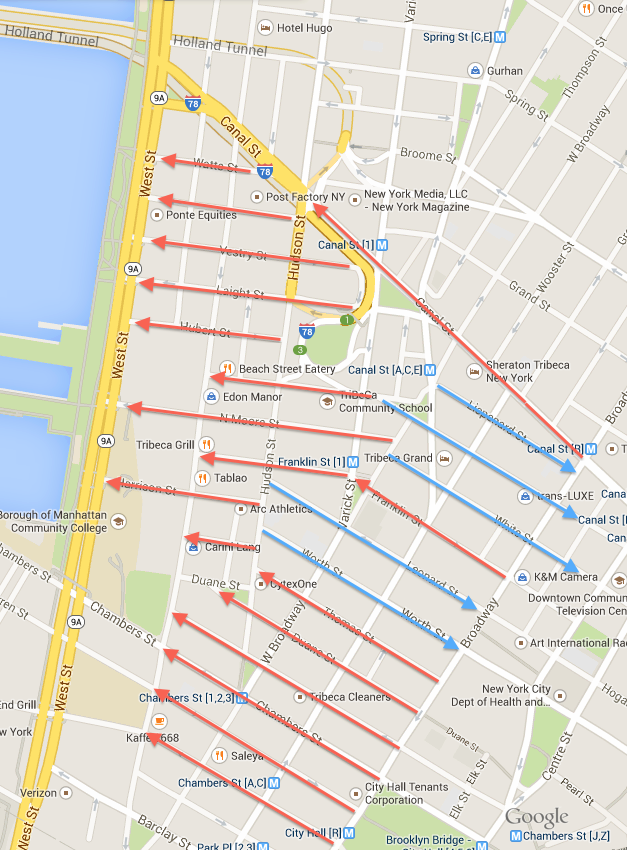 A couple of days ago, Sue asked why the street numbers on Reade—even on the north, odd on the south—differ from the New York City norm. And I added a question of my own: In the above map, the blue arrows indicate streets where the street numbers start from the west; red arrows indicate street numbers increasing from the east. James pointed out that the likeliest person to have an explanation is Hector Rivera, Topographical Bureau Associate at the Manhattan Borough President’s Office. Here’s his response:
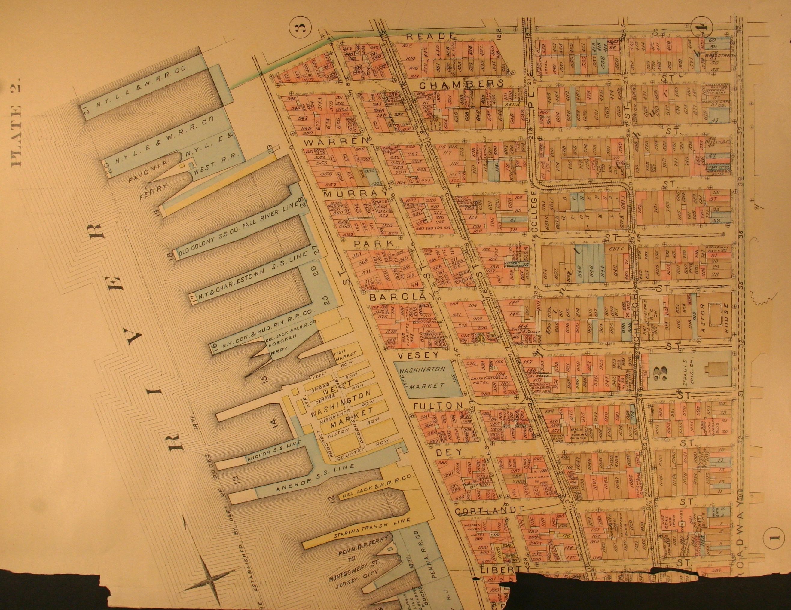
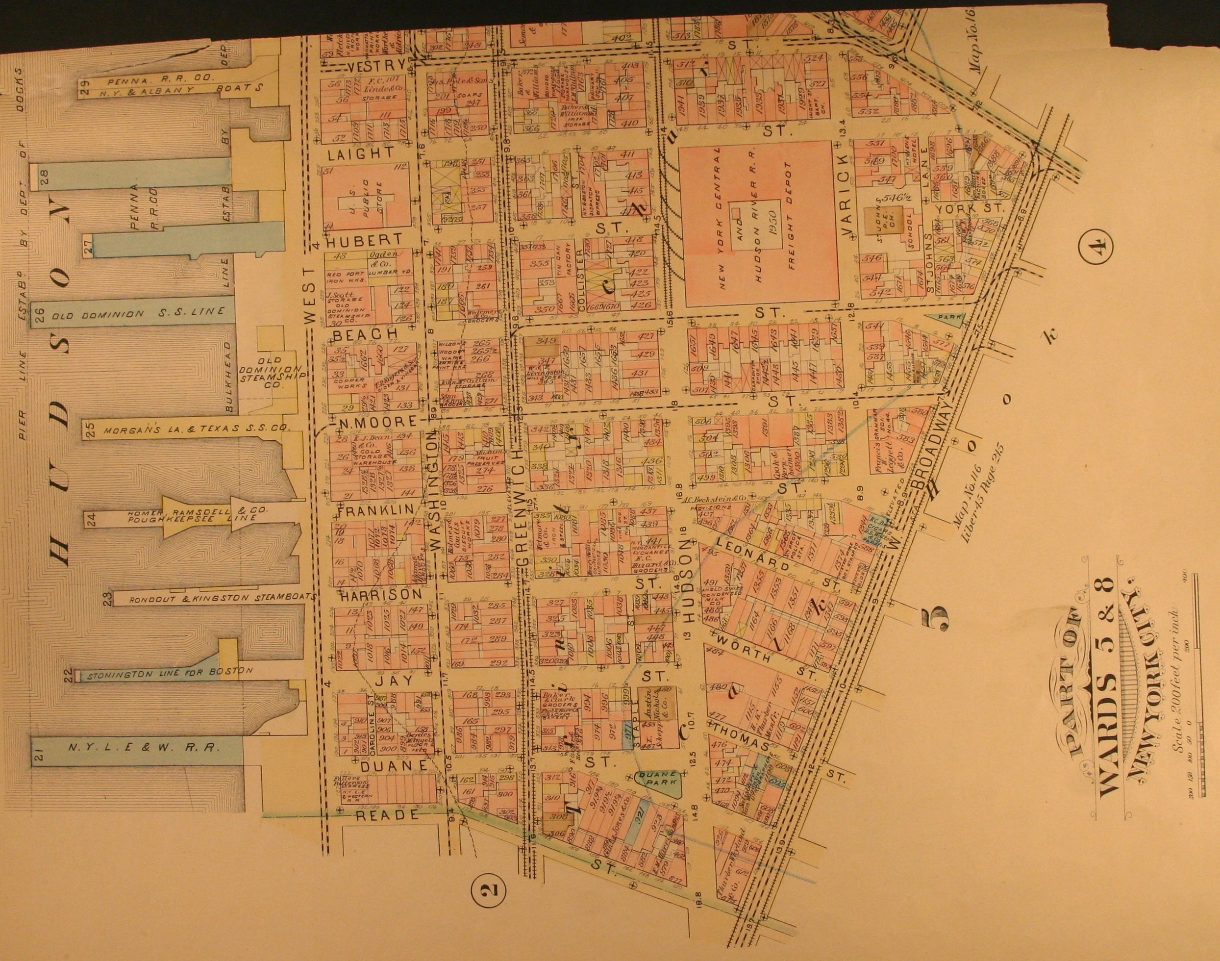
Downtown Manhattan is the oldest part of the City of New York that had open public streets before the 1811 Commissioners Plan laying out the grid street system north of Houston Street, Greenwich Avenue and West 14th Street. These properties had addresses associated with them before the rules were approved to create consistency in house numbering for the Borough of Manhattan City of New York. Attached [below] is a map showing the east and west numbering in some parts of downtown Manhattan and photos of a land book from the year 1885 showing penciled in house numbers for the areas in question. [In my email to Rivera, I mentioned Sue’s question about Reade and used Worth as an example of the direction question.] Reade Street opened to the public the year 1760. Worth Street opened to the public the year 1800. Clinton Street, opened to the public the year 1760, starts with 1 at East Houston Street and increases going south to South Street. West Street and South Street have odd and even numbers due to when they were issued they did not think there would be a need for house numbers on the other side of the street.
As the city continues to grow and new buildings are constructed I have to try and make sense of the existing numbering system.
I don’t envy that job! James, however, might. Only after I had reached out to Rivera did I see that James had delved into the matter himself. Here’s his report:
There are other streets downtown besides Reade Street with even numbers on the north side of the street, including as I recall Broome Street, Grand Street, Desbrosses Street, Vestry Street, Laight Street, Hubert Street, Walker Street, White Street, Franklin Street, Warren Street, and Wall Street (the last is numbered from Broadway and increasing going east).
Here is what I have gleaned from reading laws and secondary sources* about the history of street addresses online:
(1) Odd/even on north/south sides of the street and exceptions.
In 1793/94 the first law regulated uniform street numbers in New York is passed, separating odd and even numbers on opposite sides of the street, mandating the installation of street signs and the posting of permanent house numbers on buildings. That said, the regulation is not the clearest in trying to mandate odd numbers on the north side:
“Beginning at the next House in every Street terminating at either of the Rivers where such a Street intersects the main Street next to the River and all Houses below such intersecting Street to be number separately beginning with No. 1 looking upwards in all main Streets and downwards in all the Slips on the one side of the Street and No. 2 on the opposite side and so on to the end of the Street or Slip.”
Apparently house numbers were not even assigned on Reade Street until 1794.
One flaw I understand was that they numbered *existing buildings* consecutively instead of numbering *building lots* consecutively, so that both demolition of existing buildings and construction of new buildings between two existing buildings messed up the numbering scheme and then required frequent re-numberings.
(Wall Street was renumbered in 1794 to separate addresses into odds and evens. Before Wall Street was renumbered in 1845, however, it seems that the odds and evens switched sides of Wall Street part way along its length!)
In 1811 the familiar street grid was adopted for expansion north of the then-established city (with the street numbers starting from the west I understand).
In 1838 a law was enacted dividing Manhattan into East and West Sides, along 5th Avenue, north of 13th Street. House numbers started at No. 1 at 5th Avenue and grew larger going east and west as they do today.
In 1861 a law was enacted to solve the problem of construction and demolition of structures ruining the house numbering on a given street, from 9th Street north. From 5th to 6th Avenue, the numbers 1-99 would be assigned. From 6th to 7th Avenue, the numbers 100-199 would be assigned. From 7th Avenue, the numbering would start with 200, etc. etc. It is apparently from this time that streets from 9th St. north would be uniformly numbered odd on the north side and even on the south side.
(2) House numbers increasing sometimes to the east and sometimes to the west in Tribeca
According to “CHANGED HOUSE NUMBERS AND LOST STREET – NAMES IN NEW YORK OF THE EARLY NINETEENTH CENTURY AND LATER” By Henry B. Hoffmann (published in THE NEW-YORK HISTORICAL SOCIETY QUARTERLY BULLETIN Vol. XXI JULY, 1937 No. 3),
“There are four basic types of house-number change which have taken place in New York City. There is a simple shift of house numbers, generally increasing the number of house numbers used in a given distance, and generally affecting different parts of the same street differently. […]
“The second type of renumbering is that necessitated by extension of a street at the end where the numbers formerly began (e.g. Cedar Street in 1829 and Canal Street in 1837 [extended east of Centre Street as I recall]) ; and the third type occurs when two or more independent streets, joining at the ends, are merged into one. […]
“A fourth type is the reverse of the third: one street or avenue becomes two or more. Finally, there is the appearance and disappearance of ‘Places’ and ‘Squares’ as addresses. These are little independent systems of house numbers, often alternative to the regular house numbers, but confined to one block, or at most a few blocks, of a given street or streets, and usually on one side of the street only. ”
Hoffmann gives the following interesting example of a street merger resulting in new house numbering on a Tribeca street.
“One more change downtown deserves mention here, the union of Franklin Street and Provost Street under the name of the former. The original Franklin Street had been laid out around 1800 as Sugarloaf Street, in the Calk Hook farm, and, like White Street, numbered from the west end, with the odd numbers on the south side. On receiving its present name, in 1811, it retained the original house numbers. Provost Street, one of the Trinity Church farm group of streets on the west side, met it at the foot of Varick Street, at Chapel (the modern West Broadway), and in 1833 it was annexed by Franklin Street. To make the numbers continuous, it was decided to reverse them on the original Franklin Street, numbering west from Orange (Baxter) Street. As a consequence, the Franklin-street Reformed Church (officially the Northwest Church), which had been Old No. 17, became New Number 107-111.”
Note that this may explain why modern Franklin Street east of West Broadway is an anomaly among the nearby streets to the north and south regarding in which direction the house numbers increase. Also it demonstrates that the original discontinuity at what is now West Broadway and Hudson Street—i.e., the east edge of the Trinity Church lands—may explain the observed differences in the direction of increasing house numbers to the east and west of West Broadway/Hudson Street.
*Secondary sources:
“‘A regular state of beautiful confusion’: governing by numbers and the contradictions of calculable space in New York City” by Reuben Rose-Redwood in Urban History / Volume 39 / Issue 04 / November 2012, pp 624-638
“House Numbering” in The Encyclopedia of New York City: Second Edition edited by Kenneth T. Jackson, Lisa Keller, Nancy Flood
City on a Grid: How New York Became New York by Gerard Koeppel
Remarkable Rise of Eliza Jumel: A Story of Marriage and Money in the Early Republic by Margaret Oppenheimer
“Alexander Hamilton Landmarks. The New Morgan Building in Wall Street” in the Nineteenth Annual Report, 1914, of the American Scenic and Historic Preservation Society; Documents of the Assembly of the State of New York, Volume 35, 1914
 Got a question? Email tribecacitizen@gmail.com.
Previous Nosy Neighbor posts:
• What are those two distinct white bands on 1 World Trade Center’s antenna?
• Why are there hay bales at construction sites?
• What’s that terrace above Le District?
• What’s happening on the old Aloha Rag space?
• When is DanceBody going to open?
• What’s the white stuff all over Northwest Tribeca?
• Why has construction stopped at 30 Warren?
• Why is Tribeca Tower’s plaza still closed?
• What’s this restaurant opening on Spring Street?
• Why is the MTA parking buses on Church?
• Is that a Dan Flavin artwork on Worth?
• What’s the deal with 79 and 81 Warren?
• Is work finally starting on 172 Duane?
• Is this parking lot at risk of getting developed?
• Why do buses have backward flags on the windows?
• What are cars doing on the Esplanade?
• How do these metal braces work?
• Is Franklin Place really a private street?
• Where are the World Trade Center soldiers based?
• What are these new blue parking signs?
• What’s this thing embedded in the sidewalk?
• Where can I buy photos of old Tribeca?
• Wasn’t the World Trade Center Greenmarket supposed to be open by now?
• Why are these people gathering on Broadway?
• What are those things at Warren and Church?
• Why does 3 World Trade Center have tailpipes?
• What’s that thing on 60 Hudson’s roof?
• Why is this statue behind a fence?
• Why does 1 World Trade Center look so unfinished at night?
• Why do Brookfield Place’s escalators run that way?
• Why is the Duane Park flag almost always at half-staff?
• Where can I get breakfast in Tribeca?
• Who are the Goatsingers?
• Why was this cornice removed?
• What are those doodads on 60 Vestry?
• What’s up with the exposed wall at 111 Murray?
• What’s inside the base of 7 World Trade Center?
• What’s the Supermarket?
• What’s happening at 172 Duane?
• Is this rooftop addition legal?
• Who’s painting those faces all over?
• What are those panels on the sanitation garage?
• How many fake restaurants are on Seamless?
• Why is 15 Warren painted that way?
• Where do Laughing Man’s profits go?
• When will FiOS come to Tribeca?
• What’s up with 60 Hudson?
• What goes on at 444 Greenwich?
• Why are Goldman Sachs’s lights always on?
• Who’s responsible for the snowflake lights?
• Why does cobblestoning require sprinklers?
• Do newspaper boxes need permits?
• Why does 161 Duane say “Whalebone”?
• What’s the story behind those Harrison townhouses?
• What’s that thing at W. Broadway and Leonard?
• Are buses allowed to idle on Laight?
• Can you recommend any Tribeca picture books?
• Who enforces sidewalk-café regulations?
• What do the characters on 47 Vestry mean?
• Where was the original Blues Bar?
• Can we walk on the West Street medians?
• What’s the story behind the lights at 289 Church?
• What’s the Dream House at 275 Church?
• How come film shoots have a trailer with doors marked “Lucy” and “Desi”?
1 Comment
Comment:
Medium rectangle #1 (top)

Right column rectangle ads


Mega rectangle

Restaurant guide icon


Harrison Street numbers begins at Hudson Street goes from East
to West. with even numbers on the North side and odd numbers on the South side, That is how the Street is numbered.